London Map Through the Eyes of AI
This project aims to explore how machines "see" the world by visualizing machine vision through maps. The main idea is to use a land cover classification model (DeepLabV3) to generate a segmentation map from a satellite image. This prediction map is then fed into a pre-trained image-to-image translation model (Pix2Pix) to reconstruct a satellite-like image from the machine's interpretation.
By comparing the original satellite image with the one generated from the machine's perspective, the project aims to reveal how machines process and reconstruct visual data. This comparison can create insights about the differences between human and machine perception and raise critical questions about the reliability of machine generated information. Should we trust machine vision to represent reality precisely? And what are the outcomes when machines "imagine" or "hallucinate" details that may not exist?
Process
Phase I: Converting the London Satellite Image Into Segmentation Mask
Phase I — Step 1: Feeding the London Satellite Image Directly Into the DeepLabV3 Model
Firstly, I wanted to see whether the model will work without training. I exported a ".tif" image of London from Google Earth Engine using the below code.
// Define a bounding box over London
var london = ee.Geometry.Rectangle([-0.55, 51.28, 0.3, 51.7]);

// Load Sentinel-2 image collection and filter
var s2 = ee.ImageCollection('COPERNICUS/S2_SR')
  .filterBounds(london)
  .filterDate('2023-06-01', '2023-08-31')
  .filter(ee.Filter.lt('CLOUDY_PIXEL_PERCENTAGE', 10))
  .median()
  .clip(london);

// Center map on London and show image
Map.centerObject(london, 10);
Map.addLayer(s2, {bands: ['B4', 'B3', 'B2'], min: 0, max: 3000}, 'RGB');

// Export as image
Export.image.toDrive({
  image: s2.visualize({bands: ['B4', 'B3', 'B2'], min: 0, max: 3000}),
  description: 'London_Satellite_Image',
  scale: 10,
  region: london,
  fileFormat: 'GeoTIFF'
});
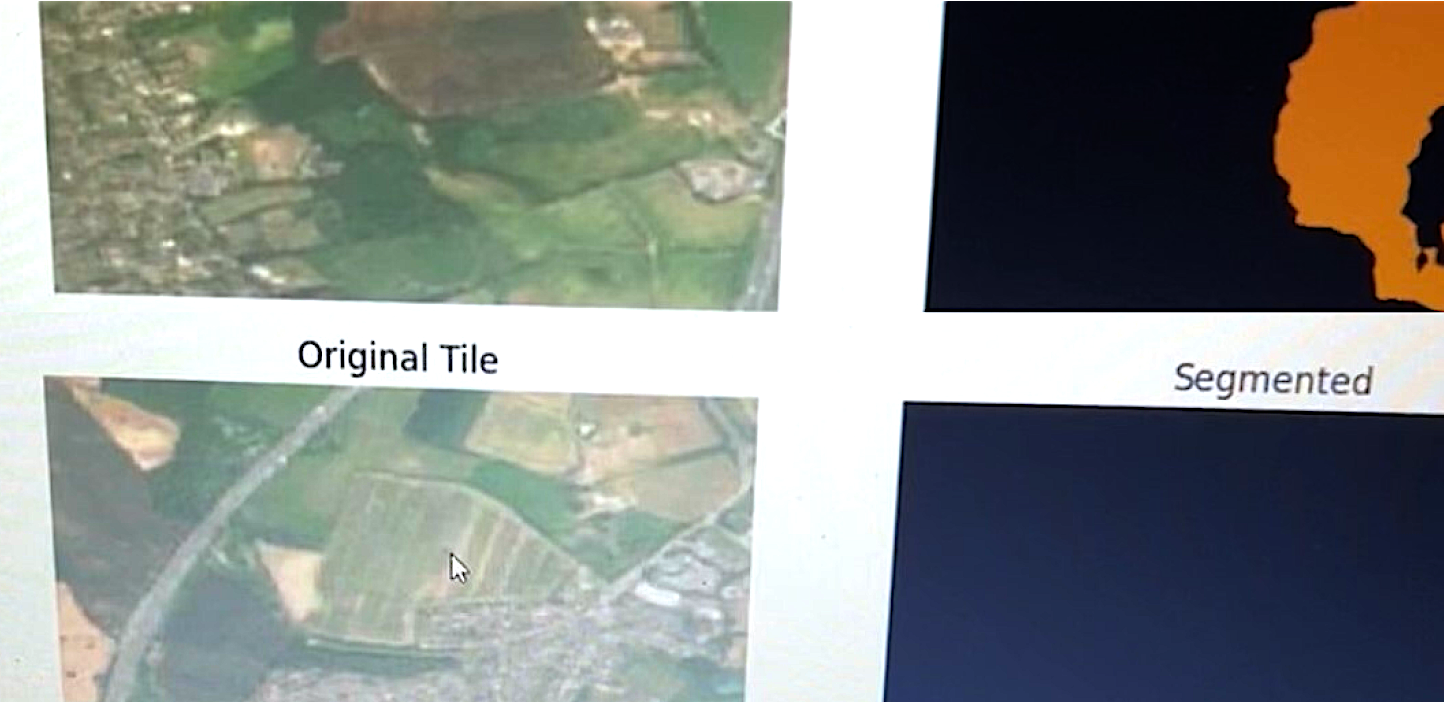
I imported the downloaded file into Google Colab, and split it into tiles. I loaded the pretrained DeepLabV3 model into Google Colab, transformed the images to be interpretable by the model and then fed them into the model. The output of the prediction masks were all black with occasional cases of color popping up randomly. I learned that this was because the model has never seen satellite images before, and it cannot interpret objects like rooftops, roads, parks, water. Therefore I needed to train the model to recognize these images.
Phase I — Step 2: Training the Model with Google Colab GPU
To train the model, I used the Deep Globe Land Cover Dataset. I imported this dataset directly into Google Colab using the below code block.
from google.colab import files
files.upload()  # Upload kaggle.json here
!mkdir -p ~/.kaggle
!cp kaggle.json ~/.kaggle/
!chmod 600 ~/.kaggle/kaggle.json

# Download the dataset
!kaggle datasets download -d balraj98/deepglobe-land-cover-classification-dataset

# Unzip
!unzip deepglobe-land-cover-classification-dataset.zip -d deepglobe
The file structure of the dataset included both segmentation masks and the satellite images as pairs in the training folder. After confirming the file structure, I created a Dataset Class and then applied transforms to be readable by the model. ChatGPT insisted that I should feed the masks as grayscale images because that's how segmentation masks work where each greyscale pixel represents a class. Although it didn't make sense, I transformed the images into greyscale using:
mask = Image.open(mask_path).convert("L")Then I created a data loader. I learned that DeepLabV3 is normally trained to predict 21 different classes, however the DeepGlobe dataset only involved 6. As a result, I ended up modifying the model as below:
model.classifier[4] = torch.nn.Conv2d(256, 6, kernel_size=1)Once I attempted to train the model, the GPU usage limit of Google Colab ran out, so I ended up using local GPU.
Phase I — Step 3: Switching to Local GPU
I switched to local GPU by running the coding environment in my local laptop. I used the local host link to connect to Google Colab. After this, I had to make some tweaks in the code, since I was uploading the DeepGlobe dataset without any downloads. I repeated the other steps above, and I finally was able to train the model. The first results were not satisfactory although the learning rate seemed to be good. The model produced masks that are almost randomly colored, in an unrelated way to the information on the original satellite image.
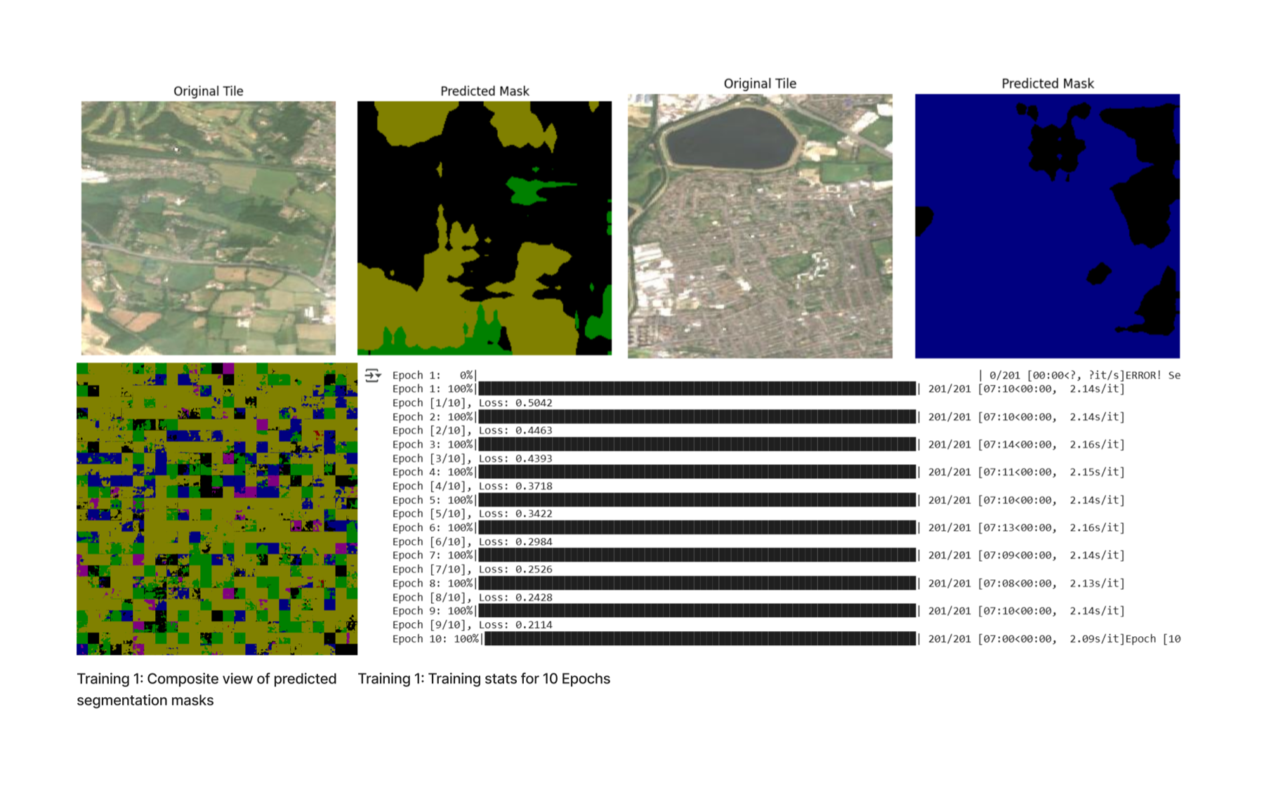
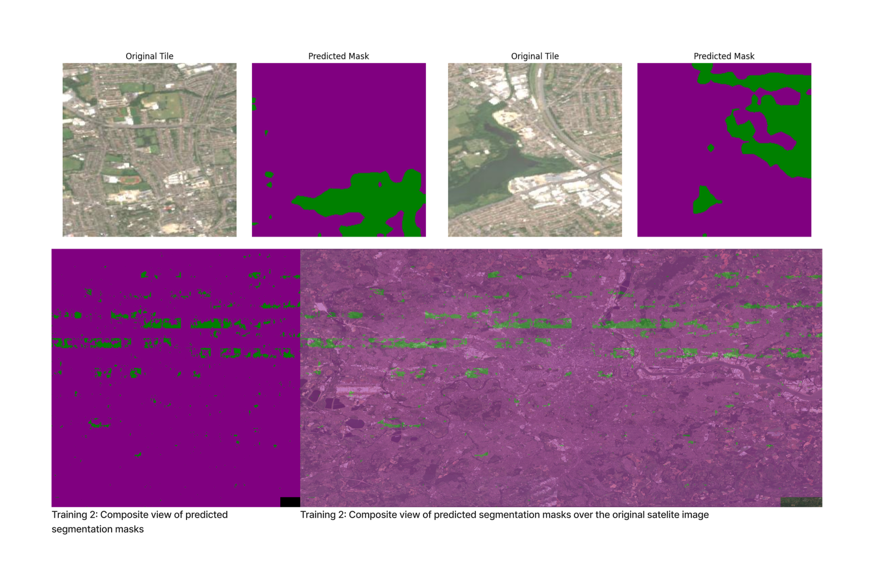
To solve this problem, I decided to retrain the model making some changes in the code. I changed the optimizer from Adam to AdamW, increased the number of epochs from 10 to 20, rearranged the image transformations to be more adaptable for the model. Furthermore, I changed the model architecture to use DeepLabV3+ResNet50. I used the L2 regularization method to prevent overfitting by implementing "weight_decay=1e-5" to the optimizer steps.
optimizer = torch.optim.AdamW(model.parameters(), lr=1e-4, weight_decay=1e-5)This time, the loss value started very high and did not go below 0.1. The resulting prediction masks were noticeably worse, consisting of only two colors over the whole satellite image. Similarly with the previous training, the textures that were generated in the prediction masks were unrelated to the information on the original satellite images.
Phase I — Step 4: Fixing the Deep Globe Dataset
After giving it some thought, I realized where the issue might be coming from. ChatGPT was insisting that I should feed the masks into the model as greyscale images while training. This might have caused the model to misinterpret the classes. Secondly, the mask-image pairs may not have been correctly fed into the model, potentially causing it to associate incorrect images with masks and learn inaccurately. As a result, I decided to debug the training process, focusing on these issues.
Like in the previous phases, I started by uploading the Deep Globe dataset into Google Colab. Then, I checked the path structure in the dataset, and realized that the validation dataset did not involve the prediction mask and satellite image pairs. Therefore, I realized that I should change the validation process. Later, I assigned each RGB value in segmentation masks, in the dataset to the class they represent. I used the below code to parse and convert the RGB mask into a class index and to make sure that the mask-image pairs are correctly assigned.
import os
from PIL import Image
import numpy as np
import torch
from torch.utils.data import Dataset
from glob import glob
import pandas as pd

def load_class_map(csv_path):
    df = pd.read_csv(csv_path)
    class_colors = {}
    for _, row in df.iterrows():
        rgb = (row['r'], row['g'], row['b'])
        class_idx = row['class']
        class_colors[rgb] = class_idx
    return class_colors

class DeepGlobeDataset(Dataset):
    def __init__(self, root_dir, class_dict_path, transforms=None):
        self.root_dir = root_dir
        self.transforms = transforms
        self.class_colors = self._load_class_colors(class_dict_path)

        self.image_paths = sorted(glob(os.path.join(root_dir, '*_sat.jpg')))
        self.mask_paths = sorted(glob(os.path.join(root_dir, '*_mask.png')))

        self.image_paths = [img for img in self.image_paths if self._find_mask(img)]
        self.mask_paths = [self._find_mask(img) for img in self.image_paths]

    def _load_class_colors(self, csv_path):
        df = pd.read_csv(csv_path)
        color_to_class_index = {}
        for index, row in df.iterrows():
            color = (row['r'], row['g'], row['b'])
            class_index = index
            color_to_class_index[color] = class_index
        return color_to_class_index

    def _find_mask(self, image_path):
        base_id = os.path.basename(image_path).split('_')[0]
        mask_path = os.path.join(self.root_dir, f'{base_id}_mask.png')
        return mask_path if os.path.exists(mask_path) else None

    def _rgb_to_class(self, mask):
        mask = np.array(mask)
        h, w, _ = mask.shape
        label_mask = np.zeros((h, w), dtype=np.uint8)
        for rgb, class_idx in self.class_colors.items():
            matches = np.all(mask == rgb, axis=-1)
            label_mask[matches] = class_idx
        return label_mask

    def __len__(self):
        return len(self.image_paths)

    def __getitem__(self, idx):
        image = Image.open(self.image_paths[idx]).convert('RGB')
        mask = Image.open(self.mask_paths[idx]).convert('RGB')
        mask = self._rgb_to_class(mask)
        if self.transforms:
            image = self.transforms(image)
        mask = torch.from_numpy(mask).long()
        return image, mask
To be sure that the mask-image pairs are correctly assigned before being fed into the model, I displayed three consecutive pairs.

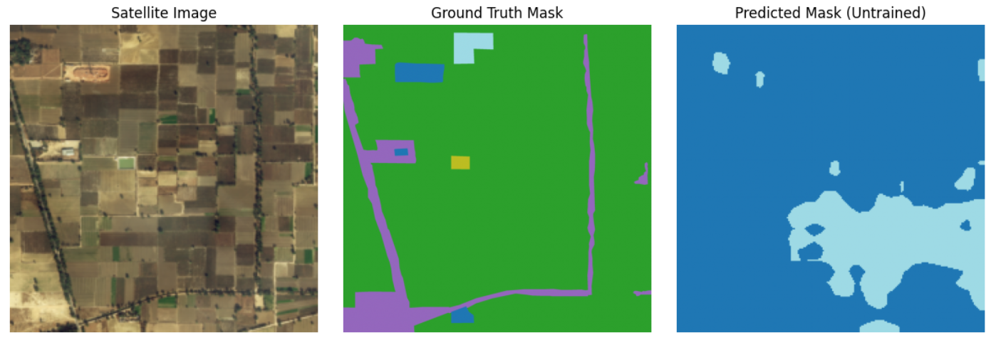
To compare the results after training, I made the untrained model predict a mask from one of the satellite images in the dataset.
I repeated the processes of formatting the dataset, initializing the DeepLabV3 model with ResNet50, adding a Conv2D layer, setting up the Adam optimizer and CrossEntropyLoss function, defining the batch size and number of epochs, and transferring the model to the GPU. After making sure that the dataset and the model is prepared without any errors, I pushed them into training. This time I calculated both training and validation losses.
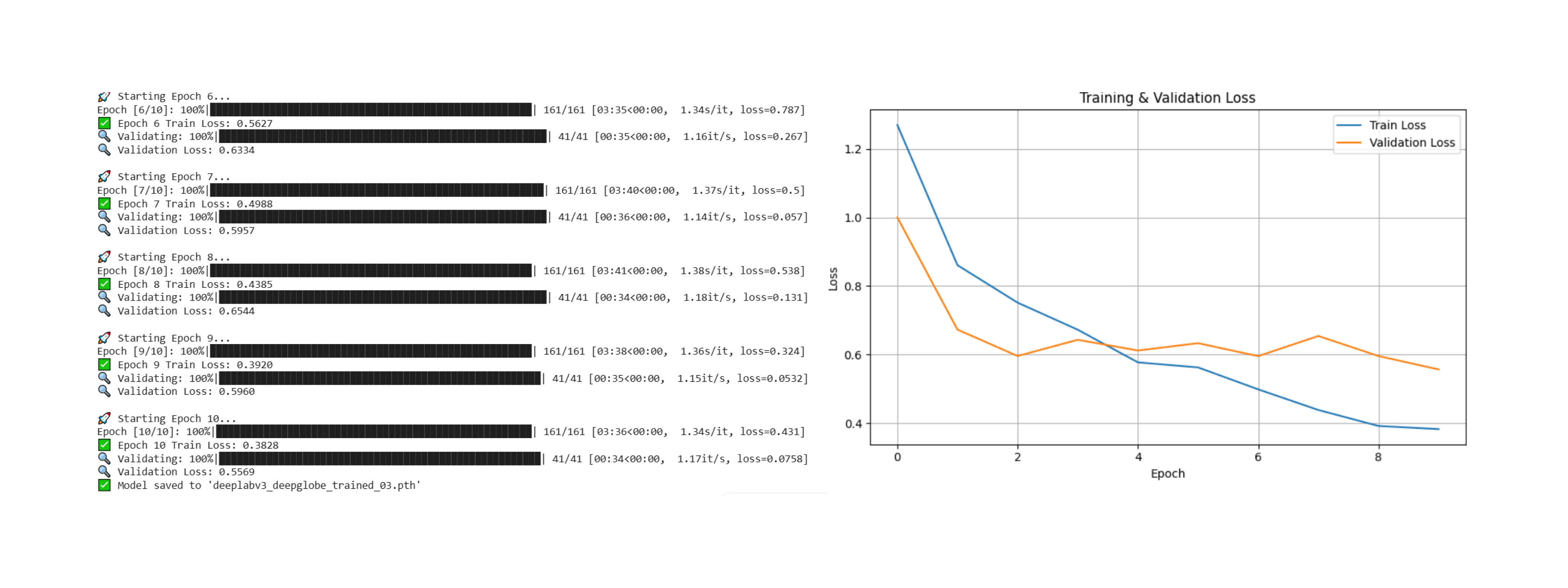
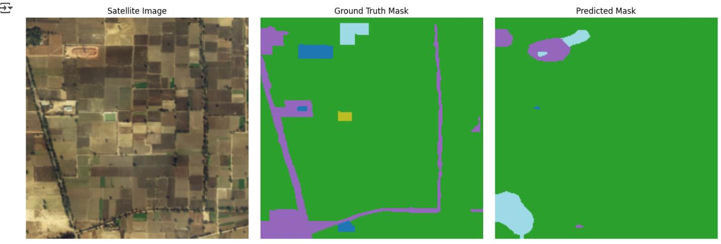
After training is done, I saved the model and loaded it to use on my dataset. Before passing my dataset into the model, I wanted to ensure that the training was accurate. I repeated the step of displaying the original satellite image, the ground truth mask, and the predicted mask side by side, this time using the trained model.
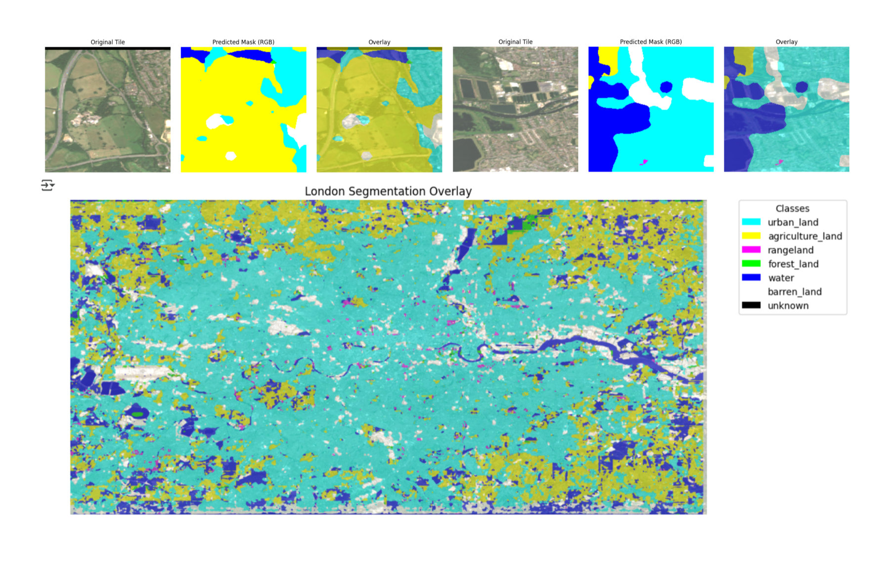
Later, I imported the London Satellite image I downloaded from Google Earth Engine, and split it into tiles. I made sure that the tile sizes and zoom level matched the training data. I fed the London Satellite Image tiles into the trained model. Finally I displayed the composite view of tiles, on top of the original satellite image, with labels that indicate the classes. The produced segmentation masks were more accurate than the previous trainings. The model was almost correctly able to distinguish between agricultural zones, urban areas, water elements and etc. Since my idea was to show how machines make mistakes, I did not want to retrain the model for a more precise outcome. I was ready to move on to the next phase.
Phase II: Converting the Composite View of Segmentation Mask back Into Satellite View
My aim was to feed the produced tiles into a pretrained Pix2pix model, to reproduce a satellite image. Although I attempted to clone the repository to reuse it, I ran into several issues. Due to lack of time, I decided to work on this phase in the future.
Thoughts
This project taught me how to prepare datasets and carefully select the models, to achieve the desired outcome. I think DeepLabV3 is not ideal for my project. It was originally designed for detecting and classifying objects in images from a human-eye perspective, where objects appear in large scales and are more distinguishable. In contrast, in satellite images, the point of view is from above, and the objects are scattered in small scales, lacking clear boundaries. This inconsistency highlights the importance of aligning the model choice with the characteristics of the dataset.
The processes I went through during the project act as a reminder not to rely solely on machines for accurate interpretation and representation of information. While machine intelligence is faster and more powerful than human cognition in many tasks, it lacks the flexibility required to adapt its reasoning methods among different types of datasets. A specific model is trained for a narrow purpose and has trouble generalizing outside of that scope. I believe that the adaptability and the contextual awareness of the human mind have not yet been replaced, and that gives us a reassurance that our jobs are still safe.
Resources
- Berrios, I. (2023). DeepLabv3: Building Blocks for Robust Segmentation Models. Medium. Link
- Demir, I. et al. (2018). DeepGlobe 2018: A Challenge to Parse the Earth Through Satellite Images. Dataset
- Google Earth Engine (2019). earthengine.google.com
- Isola, P. et al. (2017). pix2pix: Image-to-image translation with conditional adversarial networks. Link